The Map of Egypt: A Complete Guide to Its Geography, Cities, and Borders

Explore the map of Egypt, a landscape defined by the life-giving Nile River and vast deserts. This guide breaks down the country's unique geography, from the fertile delta and Mediterranean coast to the strategic borders shared with Libya, Sudan, and Palestine. Discover how Egypt's location at the crossroads of continents shaped its history, concentrated its population along the riverbanks, and gave rise to major cities like Cairo and Alexandria.

From Ancient Times to the Present: An Overview of The Map of Egypt

Throughout history, changing lifestyles and foreign conquests repeatedly expanded and contracted Egypt’s frontiers. The region’s gifted location shaped the advancement of ancient Egyptian civilization, molding its culture and history while drawing the attention of surrounding nations.

Notable Features of Egypt’s Topography

Egypt boasts a rich and varied landscape that includes several remarkable geographical features. Here’s a closer look:

The Sahara Desert

The expansive Sahara Desert covers much of Egypt, offering an endless stretch of arid, golden sand dunes. This area defines the country’s most iconic topography and dominates the horizon across much of the land.

The Nile River Valley

One of the most critical regions in Egypt is the Nile River Valley. Although it encompasses only about 5% of the land, this narrow strip of fertile soil is incredibly significant. It supports over 95% of the population, making it the lifeblood of Egyptian civilization. Lush greenery and a stark contrast to the surrounding deserts characterize the valley.

The Sinai Peninsula

To the east of the Nile Delta lies the Sinai Peninsula. This region stands out with its rugged mountain ranges and historical significance. It’s also a top tourist spot, renowned for its pristine beaches and ancient sites, offering a unique combination of natural beauty and cultural heritage.

Coastal Plains

The northern coastline along the Mediterranean Sea and the eastern coast along the Red Sea feature thriving coastal plains. These areas have beautiful beaches and are key centers for both tourism and maritime activities.

Egypt’s topography is a blend of deserts, vibrant river valleys, mountainous peninsulas, and bustling coastal plains. Each region plays a crucial role in shaping the country’s history, economy, and cultural identity.

FUN

Ancient Egypt Map

Ancient Egypt map 3500 BCE

Egyptians have lived on the Nile River for 5000 years, but about 3500 BCE, a great deal changed on the banks of the Nile. They sought to regulate the Nile’s flood and build a sophisticated irrigation system, including dikes and canals, in order to advance the agricultural state. The ancient Egyptians were unsuccessful.

This resulted in affluence and the establishment of a hierarchy of officials who went on to achieve greatness in fields like management, architecture, mathematics, and a host of other disciplines. In 3000 BCE, the Egyptians were able to realize their full potential because of the country’s privileged geographical position.

Map of Ancient Egypt from 2500 BCE.

Ancient Egypt map 2500 BCE

The Rise of Civilization In 2500 BCE, King Menes unified Egypt through war. A powerful monarchy emerged in the Nile Valley. They established Memphis as the new capital.

Population Growth Populations surged along the Nile’s banks. Ancient towns like Heliopolis and Abydos flourished here. Today, Egyptians still cluster along the river and delta. Fertile lands sustain these dense communities, just as they did in the past.

Population Distribution Maps and datasets clarify this distribution. These tools illustrate density and demographics. Visualizing the data reveals human clustering. This highlights settlement patterns, past and present.

Exploring Ancient Sites

Visit the colossal pyramids on your Egypt tour. Egypt’s unique geography enabled their construction. Explore historic Memphis. Civilization thrived along the Nile. Follow the river north from Abu Simbel to Alexandria to discover major archaeological sites.

History and Culture These locations reveal Egypt’s rich history. Walk through millennia of achievement at Abu Simbel, Alexandria, or Memphis. Experience these magnificent riverside landmarks. See the Great Pyramids, history’s most renowned structures.

Tour Options Explore these sites via guided tours or solo adventures. Guides provide context and efficient navigation. Independent travel offers flexibility and a relaxed pace. Both options reveal the unforgettable wonders of the past.

FUN

Historical Context

The Middle Kingdom of Egypt (2050-1650 BC) was a period of weakness and division. The country saw a decline in management and artistic design. However, Egypt underwent many changes by 1500 BCE. The map from this time shows that the country had recovered from its period of weakness and division.

Ancient Egypt map 1500 BCE

As a direct result of this, the nascent kingdom of Egypt (1550-1070 BC) exerted control over public relations around the Nile Valley from both the east and the west. This period saw the empire grow into Palestine and Syria in the north and Nubia in the south, as well as the Mediterranean region.

It was also the time of renowned names such as Tutankhamun, Hatshepsut, and Ramses II the Great, as well as the time of construction at the major temple complexes at Luxor and in the Valley of the Kings.

Map of Ancient Egypt During the Persian Period

Ancient Egypt map 1000 BCE

A map of ancient Egypt dating back to 500 BCE

Ancient Map of Egypt 500 BCE

Ancient Egypt began to collapse about 1200 BCE and was subjected to several invasions, which resulted in the loss of Palestine and Nubia, among other territories. For over two centuries, Egypt served as a province of the Persian Empire after being conquered by it in 525 BCE.

10 Best Luxor Restaurants

Find your perfect meal in the heart of ancient Egypt. This guide to the 10...
Related post
FUN

A map of ancient Egypt dating back to the Ptolemaic Period.

Ancient Map of Egypt 200 BCE

During Alexander the Great’s conquest of Egypt in 200 BCE, Egypt fell under the authority of his general Ptolemy and his offspring, including the stunning beauty of the time, Cleopatra. After his death in 323, Egypt came under the rule of his descendants, including the stunning beauty of Cleopatra.

It was at Alexandria that Egypt’s capital was converted into a new city that became the hub of Hellenistic culture, resulting in the creation of a hybrid Greek-Egyptian civilization.

Egypt’s Map During the Greek Period

The Greek period came to an end in 30 BCE with the suicide of Queen Cleopatra, the last native King of ancient Egypt, following the death of her beloved Mark Anthony. This marked the beginning of the end of the Greek period. To ensure that as much grain and gold as possible could be extracted from Egypt, the Roman Empire placed it under the jurisdiction of the distant imperial capital, Rome.

Detailed map of ancient Egypt during the reign of the Romans

The Map of Egypt under the Roman Empire

The city of Alexandria rose to prominence under the authority of the Roman empire in 200 CE, and it remained one of the most important cultural centers in the empire’s Greek-speaking regions for the next two millennia. In addition to being a major grain supplier to the imperial capital of Rome, Egypt developed into a significant learning center, producing a large number of contemporary academics as a result of the precious papyrus documents preserved in the ancient Alexandria library or the desert, respectively.

A Map of Ancient Egypt during the Coptic Period (about 500 AD)

The Map of Egypt under the Coptic era

As Egypt’s economic climate came under the influence of a tiny group of extremely rich families about the year 500 CE, a general tendency grew highly prevalent. Following this occurrence, Egypt grew to become a thriving hub of Christian activity, with hundreds of thousands of monks adhering to a monastic lifestyle amid the desert’s difficult circumstances. The Christian communities in Egypt eventually became the most numerous in the world, but they conflicted with the official church in Constantinople, which despised the notion of monophysitism.

Map of Ancient Egypt During the Arab Invasion

Egypt entered a new period with the Arab invasion in 639 AD, which allowed the Egyptians the right to freedom of religion and, as a result, greeted them as liberators rather than conquerors, heralding the beginning of a new era in Egyptian history. The Arabian presence, which was limited only to the newly erected city of Fustat, had an immediate impact on Egyptian civilization.

One Day in Cairo: What to See

One Day in Cairo: What to See Many travelers ask, “What can I see in...

Related post
FUN

Detailed map of ancient Egypt under the Fatimid rule.

The Map of Egypt under Fatimid

Egypt during the Fatimid authority saw several transformations and was under the jurisdiction of a succession of governors who reported to the caliph in Baghdad, Iraq, and served under the Fatimid rulers. Arabic became the official language of Egypt as a result of the Arabization movement that swept over the country.

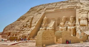
Many great structures in Cairo, such as the Amr Ibn Alas Mosque, Al-Azhar Mosque, and Ahmed Ibn Tulun Mosque, were built by Egypt’s Fatimid Dynasty to increase tax revenues and to boost the government’s tax revenues. You can visit these structures as part of a Cairo day tour, as well as other great structures throughout the world.

Egypt’s map under Saladin Ayyubid’s reign.

The Map of Egypt 1200

As a result of commerce across the Red Sea, the Fatimid were able to establish a vast empire, which enabled Egypt to become a major hub for long-distance maritime trade between East and West. Within the middle of the 12th century, a Turkish general by the name of Saladin, who dominated the nation in 1170 AD, built the magnificent Citadel of Cairo. Saladin also captured Jerusalem from the Crusaders in 1187 AD, and his successors continued to rule the city after him.
Mamluks were the rulers of ancient Egypt.

Map of ancient Egypt from the year 1453 AD.

The Map of Egypt 1450

During the reign of Saladin’s descendants, they surrounded themselves with Mamluqs, an army of Turkish slaves who, in 1453 AD, were able to take over the nation and even extend their control into Syria. Even under the Mamluks, Egypt continued to serve as the primary hub of Arabic civilization, and the Mamluks were successful in protecting the empire against the Mongol invasion in 1260. Mosques and bazaars, among other Islamic structures, were constructed during this period.

Map of Ancient Egypt during the Ottoman Empire’s reign.

The Map of Egypt 1650

After the Mamluks were defeated in 1648, the Ottomans took over as the ruling authority. After seizing power, the Ottoman Empire placed the Mamluk elite in a position of leadership to assist Egypt in its transition to a modern state of affairs.

They were able to contribute significantly to the administration of the province. Despite being marginalized by Egyptian culture and government, the Mamluks were able to establish themselves as essentially the sole rulers of the country during their reign. They defended Egypt’s southern border and maintained their respect for the Ottoman Empire’s authority throughout.

Map of Egypt under Muhammad Ali’s reign

The Map of Egypt 1789

In 1798 AD, European military forces rose to power, and the Ottoman Empire’s influence declined. The Ottoman Empire sent a Turkish general, Muhammad Ali Pasha, to control the country.

However, Muhammad Ali had other plans. By 1837 CE, he had established hundreds of schools and built a powerful Western army. He modernized the country and incited a revolt in Greece. He then took Syria from the Ottoman Empire.

Muhammad Ali wanted to expand his new kingdom beyond Egypt’s borders. He planned to depose the Ottoman ruler and take his place. In 1841, European forces compelled him to abandon his march on Constantinople and his claim to Syria. He had to settle for a new role: hereditary ruler of Egypt for himself and his descendants.

French engineers designed the Suez Canal, and Egyptian laborers built it over ten years. The British government supervised the project. The canal opened to the public in 1869.

Egypt’s map during the British Occupation of Egypt

The Map of Egypt 1914

Thousands of British troops invaded Egypt in 1914 to put down a nationalist uprising that was threatening the Suez Canal, as well as to fulfill a request from the country’s existing monarch, Ismail, to manage the country’s finances and preserve it from bankruptcy and complete anarchy.

Under Native Rule, Egypt Map 1960 AD

The Map of Egypt 1960

After World War II ended, the British government withdrew its troops from Egypt in 1947, keeping control of only the Suez Canal area. When King Farouk ascended to the throne, leaders reached an agreement on Egypt’s territorial boundaries. In 1952, under the leadership of Gamal Abdel Nasser, Egypt became a republic.

Egypt gained control of the Suez Canal but suffered the consequences of British and French military actions on the Egyptian side of the waterway. In 1958, Egypt and Syria united to form the short-lived United Arab Republic.

Recommended Tours in Luxor: Explore Karnak and Ancient Thebes

Step into the "World's Greatest Open-Air Museum" with our Recommended Tours in Luxor. From the...
Related post
FUN

Egypt’s Map Today

Egypt map 2019 egypt fun tours

After Egypt reclaimed Sinai from Israeli forces in 1973, under the leadership of the late great leader Muhammad Anwar El Sadat, the map and borders of Egypt were established and accepted by the rest of the world.

The Sinai Peninsula is more than just a reclaimed territory; it is a region of profound significance. Geographically, it features several notable mountain ranges, which not only contribute to its diverse landscape but also offer unique tourism opportunities. Located to the east of the Nile Delta, the Sinai Peninsula acts as a bridge between Africa and Asia, further enhancing its strategic importance.

Tourist Destination

The Sinai Peninsula is a popular tourist destination, known for its stunning beaches and rich historical sites. Tourists flock to its coastal areas to enjoy pristine waters and sun-soaked sands, while history enthusiasts explore ancient landmarks that tell the stories of past civilizations.

Diverse Terrain

The country’s terrain ranges from deserts and mountains to fertile river valleys and coastal plains. This diversity is encapsulated in the Sinai Peninsula, where one can find everything from arid desert landscapes to lush, fertile areas near the coast.

In essence, the Sinai Peninsula is a microcosm of Egypt‘s broader geographical and cultural richness, making it an indispensable part of the nation.

Egypt remained a moderate state with authoritarian rule for the foreseeable future. Egypt built several resorts, such as Hurghada and Sharm El Sheik (The City of Peace), in the following decades to draw attention to the natural beauty of the Red Sea River. The Red Sea coast is a popular destination for snorkeling and scuba diving, with colorful coral reefs and a diverse range of marine life. These underwater wonders make it a haven for marine enthusiasts and adventure seekers alike.

Egypt Has it All

Egypt offers a captivating blend of historical, cultural, and natural attractions, making it a top global destination. The Mediterranean coast is renowned for its stunning beaches, ancient ruins, and vibrant cities like Alexandria, all complemented by fresh seafood and leisure activities. Major cities such as Cairo, Luxor, and Aswan showcase Egypt’s rich heritage, from the Pyramids to the Valley of the Kings.

The country’s geography is defined by the Nile River, the Red Sea, and the Suez Canal, which are vital to its ecosystem and economy. Population distribution is heavily concentrated along the Nile, with visual tools helping planners manage resources effectively. Administratively, Egypt is divided into 27 governorates, each reflecting its unique culture.

Spanning over 1 million square kilometers, Egypt shares borders with Libya, Sudan, and Palestine, while facing territorial disputes like the Hala’ib Triangle. For those unable to visit, museums worldwide, such as the British Museum and the Rosicrucian Egyptian Museum, house extensive collections of Egyptian artifacts. From diving in the Red Sea to exploring serene botanical gardens, Egypt’s diverse offerings cater to every traveler.

Weather in Egypt

Family tour across the essential wonders of Egypt....
Egypt 10-day itinerary covering all classical Egypt cities....

AMAZING TOUR, SOLO TRAVELER.

I am a California woman who traveled to Egypt alone, and thanks to Egypt Fun Tours, I had a great time. Hani, Mohammed, Kamal, and David (my driver) were very professional and very knowledgeable. I appreciate how respectful they were and how protective they were of me. They showed me

More »
Transit tours in Cairo

One of the best tours I have ever had!

I was thoroughly impressed by the professionalism of this tour company. I emailed to inquire about the Cairo layover tour about 30 hours before my flight was scheduled to leave from New York. I was pleasantly surprised to get a quick response confirming the tour and assuring that a guide

More »
Isis with wings

Top-rated Tour Packages

Isis with wings