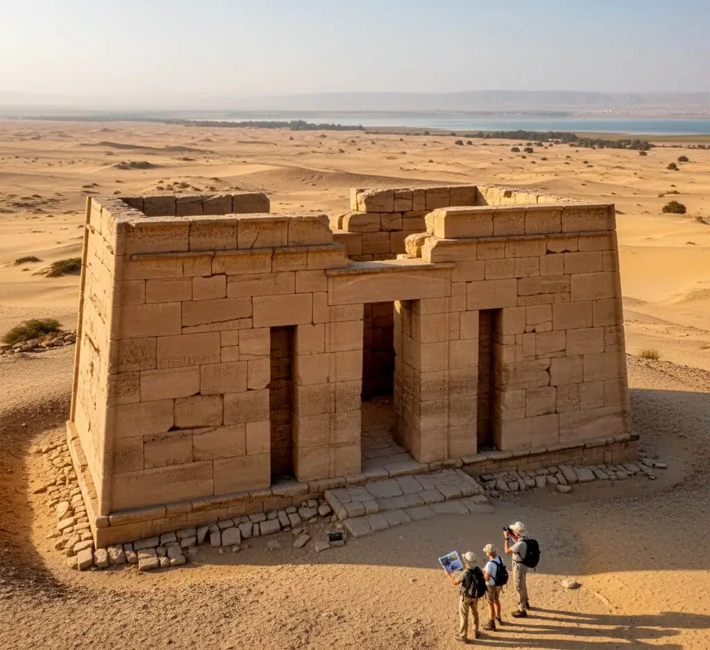
The Qasr El Sagha Temple is located north of Lake Qarun, 101 kilometers from Cairo. The name Qasr El Sagha translates as “Goldsmiths’ Palace.” The temple was lost years ago and was found by the archaeologist Schweinfurth in 1884, hiding in the desert to the north of Lake Qaroun and blending into the hills behind it. The rectangular temple is made of massive stones of local sandstone that are uneven in size and fit together obliquely.
The southern entrance, crowned by a huge lintel, leads into a spacious hallway that leads to seven roofed shrines in the northern wall. A little hallway off the central passage to the east leads to a chamber the width of the temple, while two small connected chambers lie on the western side. On the east side, there is a short tunnel in the southern wall that is accessed through the façade. Caton – Thompson, an archaeologist, discovered a primarily middle kingdom graveyard and a small settlement of stone tools, indicating that the temple was established during the middle kingdom.
The Quay
A huge amount of rock may be found around 700 meters/0.4 mile to the southeast of Qasr el Sagha. Gertrude Caton-Thompson suspected that this was a dump for the rock mined at Widan al- Faras, which was either being transported to the Nile Valley or being used to create a monument on the site. We now assume it was an old pier used to transport basalt slabs mined at Widan al-Faras across the lake.
Georg Schweinfurth discovered the location in 1884, and it is frequently called Schweinfurth’s Temple. Sir Flinders Petrie, Hanbury Brown, and Gertrude Caton-Thompson also researched it. The distance from the main road to Qasr al-Sagha is 24.6 kilometers (15 miles). A contentious new paved road is being planned. The trek takes around one hour and necessitates the use of a four-wheel-drive vehicle. The trail to Qasr el-Sagha and Dimeh begins on the left, or north, side of the Cairo-Fayoum road, 1.3 kilometers (0.8 miles) past the Kom Aushim Museum, immediately beyond a small bridge. Follow the trail for 3 kilometers (1.9 miles) until a fork, then bear right. You’ve arrived in Qasr el-Sagha via the graded road. It travels through quarries and eventually deserts. It’s rough and unpleasant. The destinations are seen about 20 to 21 kilometers (12.5 miles) from the start of the trip.
Dimeh, ahead, rises from the desert bottom like Stonehenge’s monoliths. The temple of Qasr al Sagha lies a bit to the right, halfway up a flat-topped scarp mountain. The remnants of the monastery may be seen to the right, just below the crest of Gebel Deir Abu Lifa. Continuing on, there is a sign for qasr al sagha at 22.5 km (14 miles), and the road bears right at 24.6 (15.2). The route climbs the scarp to Qasr al sagha, where there is a parking area just in front of the monument.
Deir Abu Lifa
The remains of the rock-hewn Deir Abu Lifa, Monastery of Father Lifa, located two kilometers northeast of Qasr el Sagha, high on the southeastern slope of the escarpment where it protrudes into the plain. The monastery, which was most likely built by St. Panoukhius, was in operation from the 7th to the 9th centuries and served as a refuge for Christians through difficult times. The monastery’s entryway is carved into the mountain. The monastery was founded in 686, according to inscriptions. Fayoumi mythology has it that there are hidden riches in this monastery because when the Fayoum monks abandoned adjacent monasteries, it is said they stole their valuables and buried them at Deir Abu Lifa. In 1936, Henri Munier and André Pochan paid a visit to the abbey.